

Too long, didn’t read:
The retreat isn’t new. In the Ogallala’s most depleted areas, irrigation peaked in the 1960s and has been shrinking ever since.
There’s no single Ogallala. About 90% of the water remains aquifer-wide, but on the southern High Plains, wells are running dry.
Farmers can’t pay for the transition alone. Conservation has to make financial sense for farmers, lenders, and buyers.
Why I’m not going back to the farm
My parents are winding down the farm I grew up on near Levelland, Texas. I’m not going back to farm it, and water, or lack thereof, is the reason why. There just isn’t enough irrigation capacity left for me to look at that farm and see the same opportunity my dad saw when he started in 1977, much less something I could confidently expect to hand to my own kids. It’s pretty depressing, to be completely honest. For most of my life, I’ve thought of declining irrigation in Hockley County as something relatively new.
Those of you who follow my LinkedIn and other channels know I’ve been digging deep into the data on this and other subjects lately. A couple of weeks ago, I made a map and chart that changed the way I think about the aquifer underneath the farm where I grew up. Until I made those graphics, I didn’t fully appreciate the extent to which Hockley County has been shrinking and reshuffling its irrigated footprint since the high-water mark of the 1960s. It hasn’t happened in a straight line, and the datasets themselves change over time, but the broader story is unmistakable. The county has been living with this transition for almost twice as long as I’ve been alive. On the surface, that actually made me feel a little better, but it worries me about what comes next.
A toy motor and a real one
There’s probably no better example of how normal irrigation seemed to me than one of my toys when I was little. Dad built me an irrigation motor for my third birthday. I have an old home video of me sitting on the floor playing with it, completely fascinated by this little version of the machinery running wells all over the South Plains. I didn’t know I was playing with groundwater infrastructure. It was just a motor. That was farming. Not far down the road from our place, there’s a real version sitting beside a well that’s been abandoned.
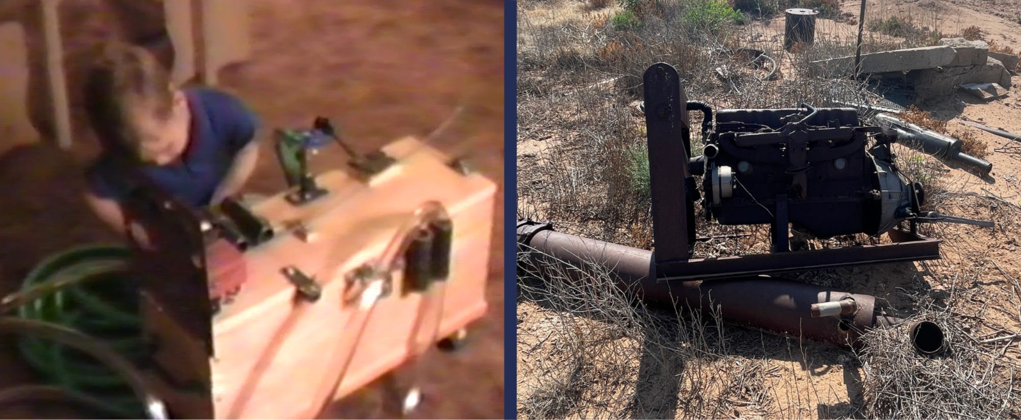
This tells quite a bit of the story for me. Decades ago, I was a kid playing with a miniature version of the machinery that helped build the agricultural economy I grew up in. Now, the real thing is still sitting there, its usefulness gone like the water it pumped. That motor didn’t become obsolete because somebody pumped the final gallon of water out from underneath the farm. There can still be groundwater under a field long after the well stops making enough water at an acceptable cost to justify irrigating the crop above it. That’s what I mean when I say the Ogallala runs out before it runs dry.
The boom was incredibly fast
I’ve learned by digging through the history of my county how new the irrigation economy really is. Hockley County already had a substantial agricultural economy before widespread irrigation. Cotton and grain sorghum were major crops in the 1930s, and farmers had learned exactly how unforgiving dryland agriculture on the South Plains could be. In 1934, the Census recorded more acres of crop failure in the county than acres actually harvested.
Then groundwater changed the risk profile for the county. By the late 1930s, there were gasoline-powered irrigation wells capable of pumping hundreds, and in some cases, more than a thousand, gallons per minute. The acreage shifts after that are nothing short of incredible. In 1939, Hockley County reported just 2,288 acres of irrigated harvested cropland. Ten years later it was 68,928. By 1954 it was 151,591 acres, and by 1964 the Census reported about 190,575 irrigated harvested acres. In roughly a generation, groundwater went from something used on a relatively small number of fields to one of the defining pieces of the county’s agricultural economy.
Then came the long retreat
This is the chart that surprised me. There are some important qualifications to make before reading it. The historical census definitions change over time, and the orange FSA series at the end is certified planted irrigated acreage rather than a perfect continuation of the earlier harvested cropland census measure. I’ve shown those breaks because I don’t want to pretend that 1939 and 2025 are one seamless statistical series.
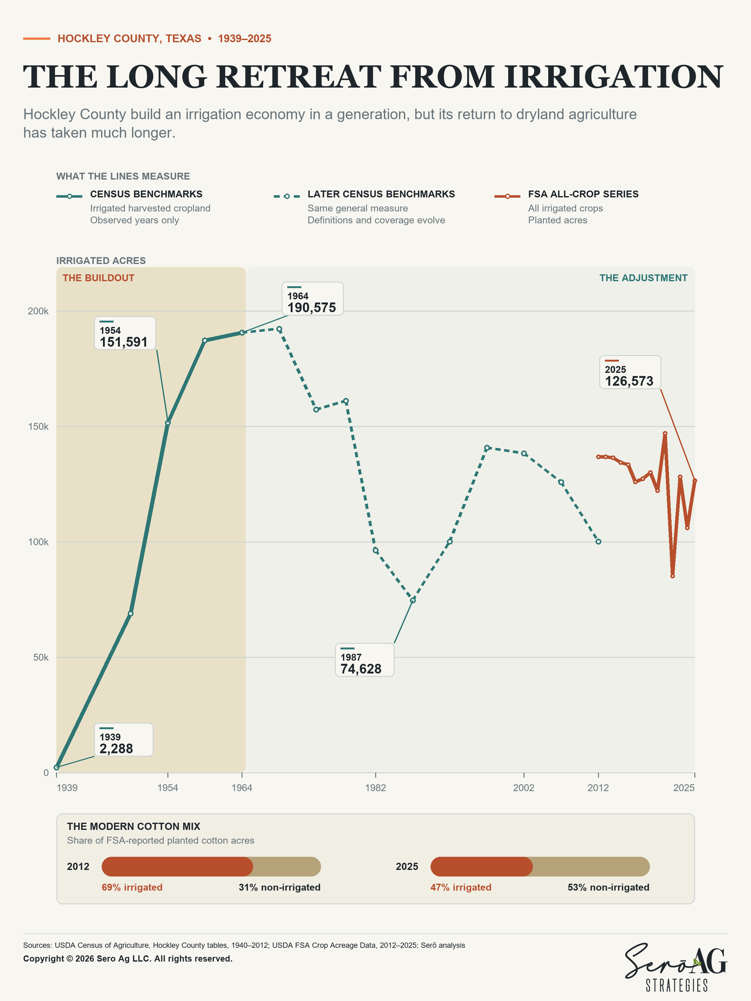
Irrigation acreage exploded from almost nothing in 1939 to something around its mature footprint by the early 1960s. After that, the story changes. There are rebounds and some big year-to-year or Census-to-Census moves, but Hockley County is no longer in the business of bringing huge new blocks of farmland under irrigation. We have been managing a mature and declining groundwater resource ever since.
The good news is we know how to adapt. Farmers have changed crops, tied wells together, reduced irrigated acreage, shifted some fields to supplemental irrigation, and let other ground transition to dryland. We have invested in better irrigation technology and figured out how to produce more with less water. The part that bothers me is what else the chart may be telling us. We’ve already used a lot of the easiest adjustment mechanisms available to us, which was simply irrigating fewer acres.
The next acre is harder
The acres still being irrigated today are the survivors. They tend to be home to wells that still make enough water, fields where irrigation continues to add enough value, or farms where somebody has invested substantial money trying to stretch the resource farther. Abandoning some underground pipe on a field decades ago was one thing. Walking away from a subsurface drip irrigation system that might represent an investment on the order of $1,500 per acre is a very different economic decision. There’s simply more capital embedded in many of the remaining irrigated acres today.
When the well underneath that investment weakens, we start talking about a stranded asset. That’s one of the reasons I think the next stage of Ogallala adjustment is going to feel different from the last one. The economics above ground have changed too. A weak well that makes absolutely no sense with cotton around 60 cents can look different if cotton prices move materially higher. Higher prices can absolutely extend the economic life of marginal irrigation. But we don’t set the cotton price in Hockley County.
Cotton is a global commodity, and Brazil has become an enormous competitor. When prices get high enough to make additional cotton production attractive elsewhere, it eventually puts pressure back on the price. So the farmer pumping a declining well is caught between the price needed to support irrigation and global demand that expects commodity pricing. That’s very different from the world in which much of this irrigation system was built, and it makes each additional step down the irrigation ladder more painful.
The strange thing is that the aquifer is still enormous
This is probably the biggest thing I wish more people understood about the aquifer. We keep talking about “the Ogallala” as though everybody above it is moving toward the same endpoint on the same schedule. They aren’t.
Much of Nebraska still has enormous saturated thickness, comparatively strong recharge and substantial interaction between groundwater, canals and surface-water systems. There are places there where long-term balance is a perfectly reasonable management objective.
Then there’s the southern High Plains, where recharge is low, development came early, and the limiting condition increasingly is whether enough saturated thickness remains to produce useful quantities of groundwater. Here, asking when “the Ogallala” will run out is a little like asking when American farmland will run out. The answer depends enormously on where you’re standing.
In 2019, USGS estimated that the High Plains Aquifer, of which the Ogallala is the principal geologic unit, still contained about 2.91 billion acre-feet of recoverable groundwater. That’s roughly 948 trillion gallons.If you somehow pumped every recoverable gallon to the surface and spread it evenly across the contiguous United States, the Lower 48 would be under nearly a foot and a half of water.
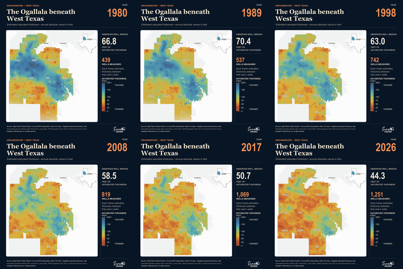
The High Plains Aquifer is nothing like an underground lake. Rather, it’s like a glass of iced tea with a straw in it, with the ice representing sand and gravel and the straw representing a well. Saturated thickness (or the amount of tea left in the glass) changes enormously from one end to the other. Recharge changes, geology changes, and the relationship with streams and surface water changes.
We’ve also already removed an enormous amount of water. USGS estimates recoverable groundwater storage declined by about 286.4 million acre-feet between predevelopment and 2019. That’s enough water to cover the entire state of Texas in roughly 20 inches of water. Texas accounts for about 169.6 million acre-feet of that net storage decline, nearly 60 percent of the aquifer-wide total.
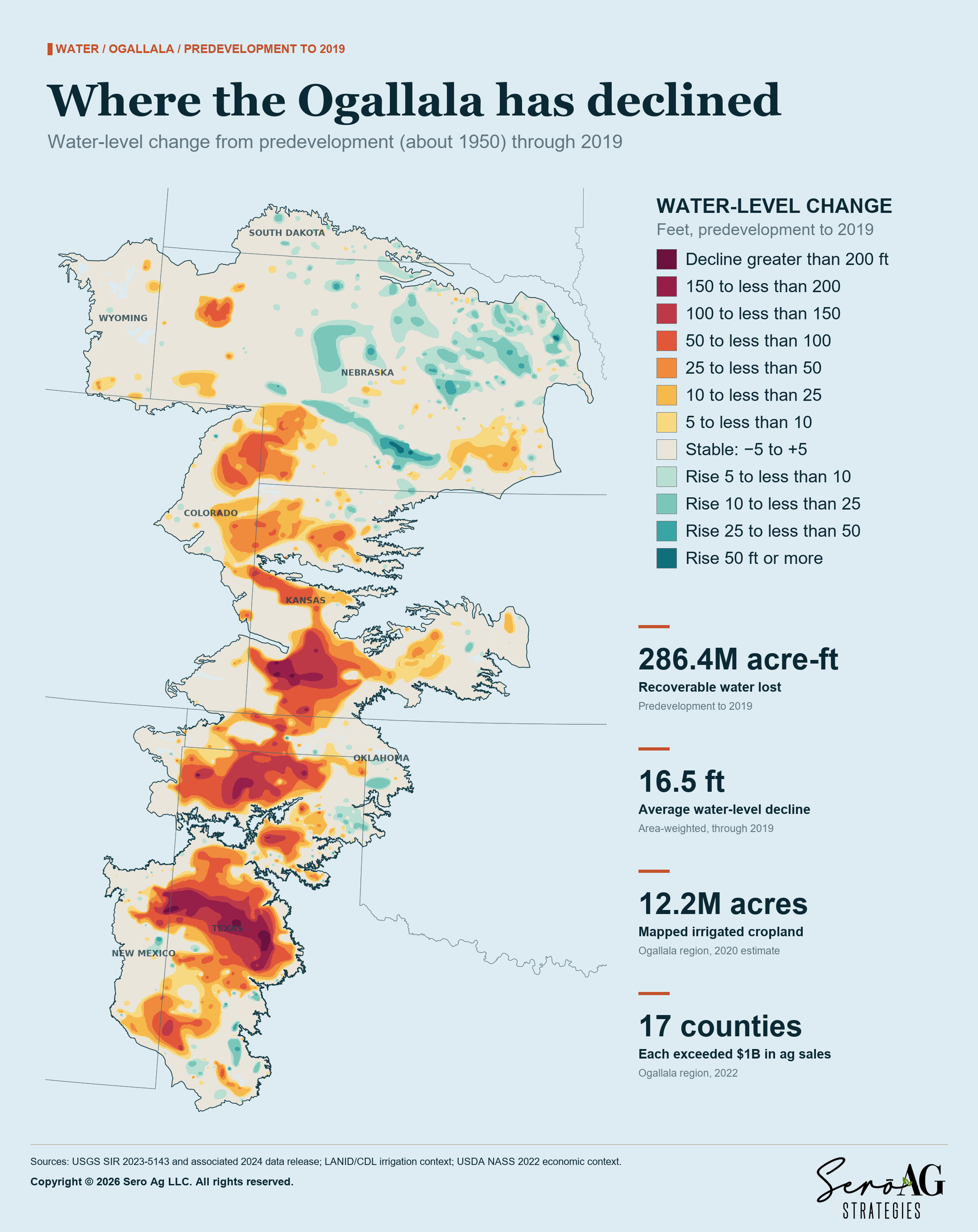
This is why an aquifer-wide statement that roughly 90 percent of the recoverable groundwater remains can be both technically defensible and almost useless to a farmer in a heavily depleted part of West Texas. You pump the well on the quarter section (or labor, a 177-acre Spanish land grant, if you grew up in my part of Hockley County) you’re standing on. Water sitting hundreds of miles away does nothing for a pump that can no longer produce enough water economically.
What we built on top of it
People regularly describe the Ogallala as the water underneath America’s breadbasket, usually followed by an enormous claim about how many people the region feeds. Detractors to this line of thought like to point out that a bushel of irrigated corn doesn’t translate neatly into a fixed number of meals. Some becomes livestock feed, some becomes ethanol and some is exported, but markets adjust and production moves to other places as needed.
I don’t think those (admittedly sometimes slightly hyperbolic) claims are wholly unfair.
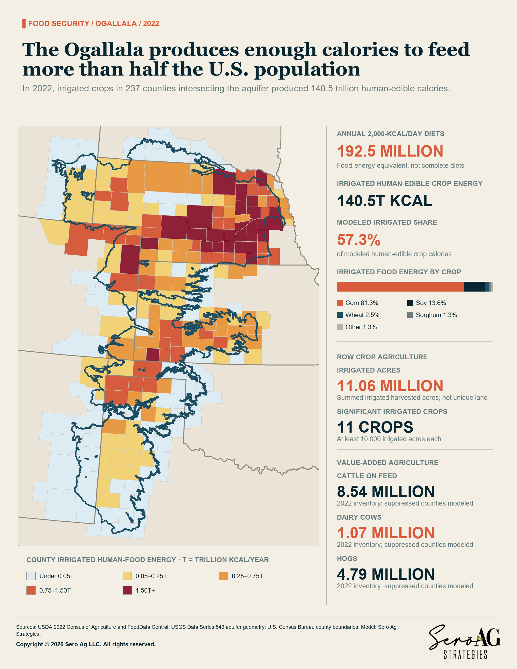
The point of looking at the Ogallala through food production isn’t to predict exactly how many people would go hungry if an irrigated acre becomes dryland. The point is to quantify how much agricultural productive capacity we have concentrated on top of a finite resource. And it’s an extraordinary amount.
We’ve tied grain, feed, fiber, meat, milk and biofuel production to this water. Then we built another layer of economic activity around those commodities. Feedlots sit where the grain is. Dairies have moved into areas where roughage can be produced economically. Ethanol plants depend on grain supply. Cotton gins, grain elevators, input suppliers, equipment dealers, processors, trucking companies, banks, and rural communities all exist within that system. The crop growing above the aquifer is just the first layer of the exposure.
That’s why I think the Ogallala belongs on the risk radar of companies and financial institutions that may never pump a gallon of groundwater themselves. Unfortunately, today, none of these actors know what to do about it.
The solution has to look like the problem
If there isn’t one Ogallala problem, there probably shouldn’t be one solution. In places where recharge and saturated thickness make long-term balance realistic, that should be the goal. In areas where the resource is already being depleted, the question may be how to stretch useful irrigation across a much longer period.
In places like Hockley County, we may be talking about something harder. We may be managing a transition toward less irrigation while trying to preserve the economic value created by the water that remains. That has to happen locally because the physical problem is local. But local cannot mean farmer-only, and this is where I think the current conversation is still badly incomplete.
If a farmer pumps another acre-inch of water, he may get additional yield this year. If he leaves that acre-inch underground, a much broader group benefits from the longer-term resilience of the aquifer and the agricultural economy sitting on top of it. In other words, the farmer is being asked to carry an immediate private cost in exchange for a benefit that gets distributed across a lot of other people. That’s not a durable economic model.
The supply chain has an interest in keeping production regions viable. Banks and other financial institutions have an interest in preserving the productive value of agricultural assets. Philanthropies and NGOs care about water outcomes. Governments have an obvious public interest, and consumers ultimately benefit from a more resilient food and fiber system. If all of those groups benefit from a more orderly transition, the cost of creating it can’t land entirely on the farmer.
We have to make the transition investable. We need to get to a point where conserving an acre-inch of water, converting a field to a lower-water production system, protecting the remaining productive life of irrigation infrastructure, or changing the crop mix can support an actual transaction. The practical test is pretty simple. Can the farmer, the lender, and the buyer all see value in leaving some of that water underground? If the answer is no, I’m not sure how we expect conservation at the scale people are talking about. In that case, the economic signal is to pump it until it’s gone and figure the rest out later.
That’s essentially what we’re doing in my part of Texas, and I’ll be the first to admit I’m part of the problem as an irrigated landowner. But I’ll also be the first to say I invested in irrigated farmland under the prevailing legal doctrine governing groundwater use in Texas, the right of capture, and my assumption in doing so was that the water was mine to use. Accordingly, I paid a certain value for that land, and that required a loan which I’m now paying back. Cut my water use, and you cut my ability to stay current on that loan. As such, I’m not too keen on reducing what I pump without the proper financial incentives.
What I actually want to save
I don’t think we’re going to refill and return the southern Ogallala to its predevelopment condition. In many places, that isn’t a serious objective anymore. I also don’t think success means preserving every irrigated acre that exists today.
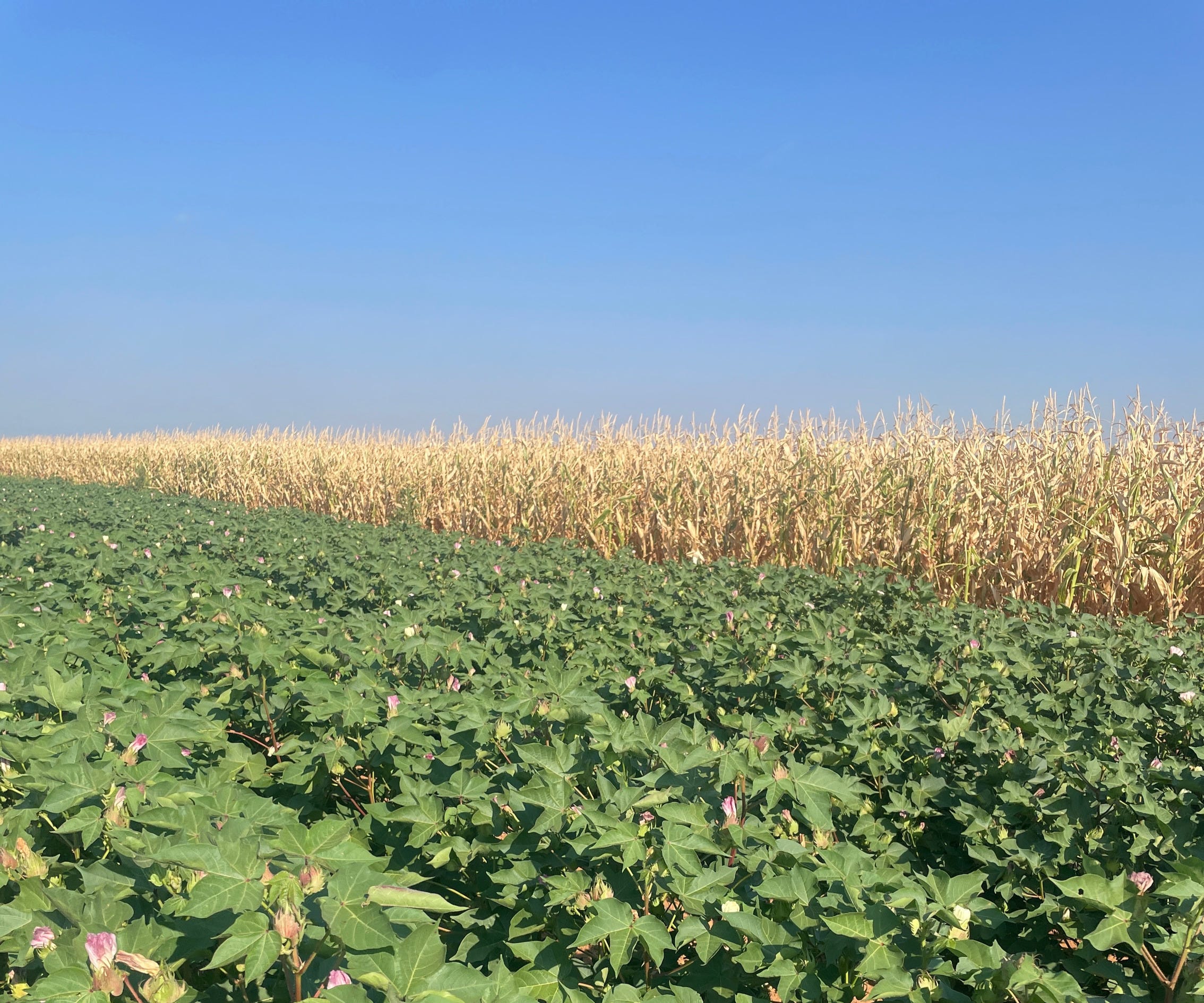
Some ground will transition to dryland. Crop mixes will continue to change, and irrigation will become more concentrated in places where the water and economics still support it. There will probably be parts of the High Plains where the agricultural economy twenty years from now looks meaningfully different from the one we know today. The thing we still have some control over is how that transition happens. I’ve now seen both ends of this story.
The question now is whether we can make the next adjustment before economics makes it for us, and whether everybody who has something invested in the agricultural economy above this aquifer is willing to help pay for it.
Recent Articles
Water conservation can’t work without economic viability in Kansas Farmer
Low nitrogen, high reward: Understanding the 45Z opportunity in Kansas Farmer
Rural America’s changing skyline is a sign of opportunity in Kansas Farmer
If you haven’t already, check out our previous newsletters.
About Serō Ag Strategies
At Serō Ag Strategies, we bridge farmers and supply chain partners by transforming complex agricultural data and policy into actionable insights. We also work to create and grow markets for commodity crops by aligning production with evolving demand, policy shifts, and sustainability goals. Combining multinational expertise with the personal touch of boutique consulting, we specialize in economic and sustainability analysis that drives strategic innovation.
Click here to learn more about Serō Ag Strategies.

Drip tech has been around for 60 years. Cotton and corn? JFC
Who TF would hire you to consult?
Reminds me of the logger who cut down the last tree....